Features
Operations
Ensuring the coast is clean …
It may seem counterintuitive to operate an aerial surveillance program with aircraft painted fire engine red and the word “surveillance” in big block letters on both sides, but that is exactly what the federal government is doing with great success.
February 27, 2015 By Paul Dixon|
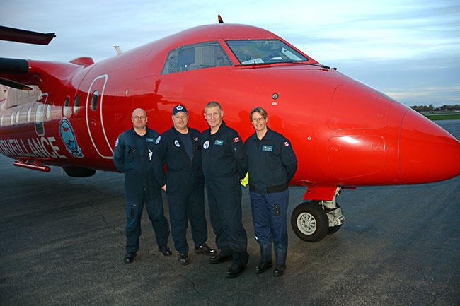 The MART team (l to r): Pilot Simon Pearce; senior technician Owen Rusticus; senior technician Bob Whitaker; and Pilot Susan Baumeler. It may seem counterintuitive to operate an aerial surveillance program
Canada has the longest coastline in the world, with more than 200,000 kilometres of saltwater coast and the Great Lakes, all of it vulnerable to pollution from a variety of sources. Transport Canada (TC) and Environment Canada have teamed up to operate the National Aerial Surveillance Program (NASP), consisting of three aircraft: a Dash 8-100 based in Vancouver covering the Pacific region, a second Dash 8-100 in Moncton, N.B., covering the Atlantic, and a Dash-7 based out of Ottawa that covers the Arctic as well as the Great Lakes.
The crews on these aircraft are made up of TC Aircraft Services Personnel and a Marine Aerial Reconnaissance Team (MART) of TC and Environment Canada specialists armed with an array of instruments and cameras to detect and record marine pollution.
Wings was recently invited to join the Vancouver crew for a day onboard its Dash 8-100 otherwise known as “Transport 951.” The day starts with a team meeting to brief the day’s mission with particular emphasis on the weather in the areas they hope to fly. The pilots on the day are Susan Baumeler and Simon Pearce, with Owen Rusticus and Bob Whitaker as the MART.
There’s a strong law enforcement connection with this unit, as three of the four team members have backgrounds in policing. Baumeler started her career with the RCMP, first in patrol and then moving into aviation, eventually flying the Citation jet. She then moved over to TC as an inspector and then back into the cockpit with the NASP and now has more than 3,000 flying hours on the Dash 8.
Pearce is the outlier, having worked his way through a variety of aviation jobs, but he knew his future was set the first time he spied the bright red airplane (a Twin Otter at that time) and said “That’s for me.” He now has more than 2,000 hours on the Dash 8.
The MART members in the back of the plane have two different policing tracks. Owen Rusticus came to Environment Canada after 13 years with the RCMP, while Bob Whitaker took a slightly more circuitous route. Born in the U.K., he served five years with the RAF before joining the Surrey (U.K.) Constabulary. Emigrating to Canada in the ’90s, he joined the Calgary Police Service and then moved further west to serve with Victoria City Police before joining TC as a maritime safety inspector at the Maritime Safety Operations Centre (MSOC).
The day’s mission is a bit of a crap shoot – it could be anywhere on the Pacific coast, depending on a number of factors. If Environment Canada’s Integrated Satellite Tracking of Pollution Program (ISTOP) has detected anomalies on the ocean surface that are consistent with oil pollution, the MART unit will be tasked for a more detailed investigation with its array of sensors and most importantly, human eyes. For all the reliance on technology, the human eye is still the best tool for determining if that really is oil on the water.
Mission duration can extend up to six hours, ranging out to the 200-mile international limit and extending as far north as Alaska. Off-shore, flying at 23,000 feet, the Side Looking Aerial Radar (SLAR) is able to cover a swath almost 100 kilometres wide. Interfaced with the Automatic Information System (AIS), mandatory on commercial vessels over 300 tons, ships can be identified and tracked by the aircraft at a great distance. Other days will see the team working the inshore waters of B.C.’s Salish Sea, Straits of Georgia and Inside Passage at altitudes as low as 1,000 feet. One of the “neat things” about the job as Pearce notes is “flying under helicopters and seaplanes.” The SLAR has limited effectiveness on the inshore waters, placing maximum attention on the Mark 1.0 eyeball.
The briefing complete, it’s time for a safety briefing onboard the aircraft. The focus on lifejackets, life rafts, survival suits and instructions on evacuating an aircraft after an ocean landing underscores the remote and harsh environments these aircraft often operate in. Securely belted into an observer’s big seat with a five-point harness, the mission starts the moment the aircraft lifts off and banks south over Richmond’s tidal shore, then heads up the main channel of the Fraser River. The river is dotted with pleasure craft, fishing boats, tug boats and ocean going freighters with a string of marinas, boatyards, industrial plants and docks lining the banks, all potential sources of pollution.
Nothing spotted, we leave the Fraser, banking over Coquitlam to enter the east end of Vancouver harbour at Port Moody and fly west from there. There are more deep sea ships in Port Moody, marinas and private docks, Kinder Morgan terminal in Burnaby, Standard oil refinery and a myriad of other industrial sites strung along the waterfront intermixed with the grain elevators, container terminals and bulk loading facilities that make up Canada’s largest port.
We head over to the Lions Gate Bridge and a quick survey of the dozen or so ships at anchor in English Bay and then a moving target presents itself: the ferry Queen of Oak Bay on the Nanaimo route passes inspection as do several tug boats and their barges. There is a continual conversation in the headphones between all four members of the team. The pilots have taken the same observer training as the MART members in the rear of the plane and they are able to give the sensor operator in the rear some potential targets to check in advance of the aircraft’s passing. To a first-time visitor it’s like trying to follow an auctioneer for the first time and constantly finding yourself half a step behind. There’s so much to see looking out the observer’s portal, especially when you don’t know what you would be looking for. A churning in the water turns out to be dozens of Pacific white-side dolphins frolicking within sight of Vancouver, but if we hadn’t flown over them you would never know they were there.
At Nanaimo, the plane banks left and we fly down the east coast of Vancouver Island, surveying marine traffic, marinas and several large industrial plants. One area of interest is near Ladysmith, where TC gathers abandoned and derelict vessels from the region. It’s negative today, but near Chemainus, the late autumn sun shows up the unmistakable sheen of oil on the water at a small marina, over an area of as much as 1,000 square metres. Scanned with the aircraft’s sensors, the amount of the spill is determined to be about 1.5 litres. Spills of more than five litres or from an identified source are reported to the Coast Guard immediately, but as this spill was neither, it will just be noted as part of the day’s report. Where the source of the spill can be positively identified charges can be laid.
Since 2004, evidence gathered by the NASP has resulted in charges from 29 incidents, with $1.86 million in penalties being levied following prosecution. At the same time, the sensor operator was capturing the data on the slick, the dilligent Wings observer on this flight was using a Nikon DSLR to capture high-resolution digital images. The MART members switch positions every hour or so to ease the strain. The concentration level is the same at both positions and the stress level is the same, but a change is as good as a rest.
Continuing on down Vancouver Island, we pass over Victoria’s Inner Harbour the provincial legislature and Empress hotel directly below, quickly followed by Esquimalt, home to the Royal Canadian Navy’s Pacific Fleet. The navy’s clean and we’re westbound over the Straits of Juan de Fuca, a target-rich environment as the only access route deep sea ships take to the ports of Vancouver and Seattle. The plane climbs to give the SLAR more room to work as the open expanse of the Pacific appears ahead and the land slips away behind us.
A ship shows up as a white dot on the black radar display at the sensor operator’s position. The display above the radar screen projects the AIS information from the ship as well as the aircraft’s flight track. It’s the MV Morning Salute, an 88,000 dwt bulk carrier outbound from the coal terminal at Roberts Bank (Port of Vancouver) for Japan. Descending for a closer look, the sensor operator uses the Wescam MX-15 electo-optical system, zooming in to verify the name of the ship from almost six kilometres out. It used to be common practice for ships to dump their bilge water, a witch’s brew of oils, chemicals and other poisonous substances into the ocean as soon as they were out of sight of land rather than incurring the expense of disposing of it while in port. The result was the death of hundreds of thousands of sea birds and the further impact on the entire food chain. The Atlantic coast suffered the heaviest toll, especially the southeast coast of Newfoundland, leading to the creation of Canada’s first aerial patrols in 1968 over the Gulf of Saint Lawrence. The program was expanded in 1991 and in March 2014 Transport Minister Lisa Raitt announced that funding would increase for the NASP over the next five years to enable a projected 75 per cent increase in flying hours.
{gallery}11656{/gallery}
The Morning Salute checks out and we head further up the west coast of Vancouver Island to check the site of where a tug boat sank off Tofino two days previously. The two crew had been rescued, but there are concerns about the fuel on board, though on this day there was no evidence of any oil in the area. There is a long history of shipwrecks along Canada’s Pacific Coast, with a popular theme being that there is at least one wreck for every mile of coastline and that is only the known wrecks. Public attention is riveted on the infrequent big events such as the Russian container ship Shimushir that was adrift off Haida Gwaii in October after losing power at the height of a Pacific storm and attention is focused on the potential environmental impact by increased tanker traffic through the Port of Vancouver and new oil terminals proposed for Kitimat. The problem today is not the off-shore pollution – which has been drastically curtailed by international awareness, off-shore patrols and advances in marine architecture – it’s the chronic pollution that comes from wrecks, abandoned vessels and industrial wastes. While the primary focus of the NASP is marine pollution, maritime safety and hazards to navigation are high on the list of priorities as well.
The site of the tug sinking is clear today, but the potential for damage to the new economy is readily apparent when flying over the area. Long Beach has become a major year-round tourist destination. The towns of Tofino and Ucluelet were built on logging and commercial fisheries, but today they have refocused to serve the international tourism boom. There may well be a shipwreck for every mile along this coast, but there is also a windswept, sandy beach around every headland. While the commercial fisheries are hanging tough, fish farms have proliferated up and down the entire coast and there are dozens of fishing lodges catering to the upscale market. It doesn’t take a large oil spill to have a huge impact on any one of these businesses.
There are several historical wrecks along the B.C. coast that the NASP monitors on an ongoing basis. The B.C. ferry Queen Of The North sank off the north coast of B.C. in March 2006, with 220,000 litres of diesel and 22,000 litres of lubricating oil on board, as well as any fuel on the vehicles carried on board. While the oil slick at the time was described as “contained” and leakage in years following described as minimal, residents of the nearby first nations community of Hartley Bay have complained about the impact on local marine life which in turn has a significant impact on their economic well being and way of life.
The NASP played a critical role in assisting the U.S. Coast Guard in the response to the Deepwater Horizon blowout in the Gulf of Mexico in 2010 and flew almost 300 hours between May 1 and July 15 Providentially, TC had participated in a major training exercise hosted by the U.S. Coast Guard where mutual aid had been a topic. The NASP was the primary aerial asset during this period and was used to determine the actual extent of the spill, identify fresh oil and direct recovery teams to the heaviest concentrations of oil.
In Canada, the NASP aircraft have provided assistance to a number of government departments including DND and DFO, as well as the RCMP. The NASP played a critical role in the apprehension of the suspected killer of three RCMP officers in Moncton, N.B. in June 2010. The Dash 8 was able to use its sophisticated sensor suite to assist in the manhunt. The infra-red sensor in the MX-15 camera system was able to identify a heat source in a specific location. The satellite communications system was utilized to stream live video from the aircraft into the RCMP command post, while an RCMP member on board the aircraft was able to provide additional communications via secure radio.
As we were approaching Vancouver at the end of our day, we had been listening to a drama unfold in the frigid waters off Jericho Beach in Vancouver. Coast Guard radio was in an extended dialogue with the volunteer rescue boat from the Jericho Sailing Club. The rescue boat, a small RHIB with a single crew member, had responded to a windsurfer in distress some distance from the shore. While the rescue boat got the now hypothermic victim to shore and waited for an ambulance, Coast Guard radio was now calling on Channel 16 for any vessel in the area to assist with a second windsurfer in distress and there was no response. Transport 951 advised the Coast Guard that we were five minutes flying time from the scene and would respond. With no lifesaving capabilities per se, the discussion on board centred on using the infra-red and video to locate the victim in the water and be able to direct any responding vessel. The situation was in hand by the time we passed overhead and we carried on to land at YVR.
The day ends as it begins, with the four team members debriefing their mission. The discussion goes around the table, with two questions asked – what went well and what didn’t? Then it’s time to write the reports and forward information as necessary. For the visitors, the day went by in a flash and it’s difficult to comprehend the area covered in such a seemingly short time. For the MART unit, it’s another day at the office and they’ll be back to do it again tomorrow in the big red bird, with one simple message for would-be polluters: We are here, we want you to know we are here and please be sure to tell all your friends.