Features
Operations
Fire And Ice: Suppressing hailstorms in Alberta
It is known as “Hailstorm Alley,”
one of the worst areas in the world for property-damaging lumps of ice
created by thunderstorm clouds. In 1991, a single hailstorm in the area
caused $400 million in damage, and from 1992 to 1995, annual losses
were about $100 million.
June 9, 2008 By Blair Watson
It is known as “Hailstorm Alley,” one of the worst areas in the world for property-damaging lumps of ice created by thunderstorm clouds. In 1991, a single hailstorm in the area caused $400 million in damage, and from 1992 to 1995, annual losses were about $100 million. Alberta is home to “Hailstorm Alley,” which runs from High River (65 km south of Calgary) to Lacombe (175 km north of Calgary) to west of Rocky Mountain House (160 km northwest of Calgary).
 |
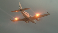
| Last season, a Piper Cheyenne II (shown here) and a Cessna 340 were based in Calgary, and a Beech King Air C90 operated from Red Deer. |
Twelve years ago, insurance companies affected by hail damage claims formed the Alberta Severe Weather Management Society (ASWMS), which contracted Weather Modification, Inc. (WMI) of Fargo, ND to provide hail suppression via cloud-seeding. This year is the 12th of the Alberta Hail Suppression Project (AHSP), which operates 24/7 from June 1st to September 15th. In 2007, about 76 cloud-seeding sorties were flown by WMI crews. The success of the AHSP is best reflected in the reduction in insurance claims of about 50% since the program came into effect. Savings of approximately $50 million each year makes the $2 million annual investment in the AHSP very worthwhile for the ASWMS.
The objective of cloud-seeding is to create or increase precipitation such as rain or snow, or reduce the formation of hail, as occurs in Alberta. Silver iodide and dry ice are used extensively for weather modification, with hygroscopic materials such as salt being increasingly employed due to promising research results.
 |
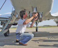
| The fine particles produced by burning silver iodide flares can be ejected into clouds from a rack mounted underneath the aircraft. |
 |
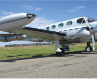
| A Cessna 340 is used to seed the cloud base. |
 |
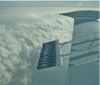
| Hygroscopic flares used in cloud seeding. |
The history of cloud-seeding dates back to the mid-1940s. While working for General Electric in New York State in 1946, atmospheric scientist Bernard Vonnegut (brother of famed novelist Kurt Vonnegut, who died in April 2007) discovered the potential of using silver iodide for weather modification.
In the same year, a GE chemist, Vincent Schaefer, dumped six pounds of dry ice into a cloud from an airplane, resulting in snow falling near Schenectady, NY.
For six years during the Vietnam War, the U.S. military carried out Operation Popeye, a weather modification program that extended the monsoon season over areas used by North Vietnamese forces. With an unofficial motto of “make mud, not war,” the U.S. 54th Weather Reconnaissance Squadron seeded clouds and extended monsoons up to 45 days. The U.S. military was also involved in cloud-seeding over the part of the Atlantic where hurricanes developed. Project Stormfury of the 1960s had the objective of modifying hurricanes to diminish their destructive power, but it was never determined whether or not the project was successful.
Two other U.S. federal agencies have supported weather modification research projects: the United States Bureau of Reclamation (BoR) and the National Oceanic and Atmospheric Administration. The former sponsored several cloud-seeding research projects from 1964 to 1988 as part of Project Skywater; the latter conducted the Atmospheric Modification Program from 1979 to 1993. The projects, which involved the study of winter and summer cloud-seeding, were carried out in several U.S. states as well as Thailand and Morocco. More recently, the BoR sponsored the Weather Damage Modification Program from 2002 to 2006.
An explanation of how hail is created would be beneficial for readers not familiar with the process. Hail formation requires the tremendous amount of water vapor and powerful convective activity present in cumulonimbus (CB) clouds, which are associated with thunderstorms. Updrafts of 10,000+ feet per minute and downdrafts of half that figure have been reported by pilots flying in CBs. The temperature in the upper portion of the CB cloud must be below freezing for hail to form, but no cooler than -30 degrees Celsius, the temperature at which super-cooled water droplets become rare.
Hail is most common in mid-latitude areas such as Alberta during summer where surface temperatures are warm enough to create the water vapor and convective activity necessary for thunderstorms, but the higher atmosphere is still cool enough to support the formation of ice. Evaporated surface water is carried aloft by warm, rising air, and reaches cooler, higher altitudes, condensing into water droplets. Caught in strong updrafts, the droplets rise above the freezing level, where they become super-cooled.
Dust whipped up by surface winds also ascends in the warm air, and when super-cooled water droplets collide with dust particles, ice crystals are formed around the condensation nuclei. Additional collisions with super-cooled droplets inside a CB cloud add layers of ice. Eventually, the ice lump—usually roughly spherical in shape—becomes too heavy and falls out of the cloud. Sometimes hail is ejected out of the side of the cloud due to the turbulence inside. The largest hailstone on record was 17.8 cm in diameter and had a circumference of 47.6 cm!
For cloud-seeding to be successful, the cloud must be cold in its upper portion and relatively ice-free, and have a steady updraft. The upper part of the cloud must be colder than -5 degrees Celsius (warmer clouds won’t develop much ice). The steady updraft is required to provide a continuing supply of moist air to above the freezing level in order for layers of ice to form around the condensation nuclei.
The fine particles produced by burning silver iodide flares mounted on frames extending aft of an airplane’s wings or ejected into clouds from a rack mounted underneath are the nuclei to which super-cooled water droplets attach themselves. Good timing and having aircraft in the right
area at the right altitude are crucial factors in effective cloud-seeding.
For the AHSP, two turbo-prop aircraft and a piston twin-engine airplane are used by WMI. For the 2007 season, a Piper Cheyenne II and a Cessna 340 were based in Calgary, and a Beech King Air C90 operated from Red Deer. The turboprop aircraft, which have a greater rate of climb than the Cessna, are typically used to seed the upper portion of the clouds, while the C340 seeds the cloud base. The aircraft are flown along the upwind side of a mature storm. Due to its greater endurance in comparison to the Cheyenne’s, the C90 is able to reach the far western part of the target area near Rocky Mountain House and remain on-station, seeding clouds.
WMI personnel consist of meteorologists, Canadian pilots, and aircraft maintenance staff. Thanks to high-speed Internet service at the Calgary and Red Deer bases, pilots are able to monitor developing storms via a feed from the weather radar at the Olds-Didsbury Airport (100 km north of Calgary). Environment Canada’s radars at Strathmore and Carvel, AB provide a back-up in case of radar failure. There can be more than one storm at a time threatening communities in “Hailstorm Alley” during the three-and-a-half month period, and WMI’s aircraft are launched to the area deemed to have the highest priority.
WMI has integrated weather radar with computer technology to produce real-time, full-sky weather observation and data archiving. TITAN (Thunderstorm Identification; Tracking, Analysis, and Now-casting) radar processing software is part of the system used in Alberta. The radar data acquisition system (RDAS) receives the raw radar data, does preliminary (calibration) processing, and passes it on to the TITAN processing and display software. The RDAS is typically programmed to control the radar antenna so that it scans the sky (a 360-degree sweep) in 18 separate height increments, up to 45 degrees of elevation.
The TITAN software receives a “full-sky” scan every five minutes, and processes the data to provide horizontal and vertical storm cross-sections, storm motion and history, estimated total precipitation, and other useful information. Also, position data from the aircraft is automatically received and displayed on the TITAN display. Data from the radar and aircraft is regularly archived and provided to
the client.
Although a 2003 report by the U.S. National Research Council concluded that “…there still is no convincing scientific proof of the efficacy of intentional weather modification efforts,” as far as insurance companies in Alberta are concerned, the Alberta Hail Suppression Project has proven its value greatly since 1996. The confidence of the ASWMS in the effectiveness of the hail suppression work done by Weather Modification, Inc. is such that the company has been contracted to provide cloud-seeding until 2010. It looks like airborne weather modification in Canada is here to stay.